Satellite Data Reveals Thousands of Underwater Mountains Never Seen Before
| Ana Verayo | | Oct 03, 2014 01:45 AM EDT |
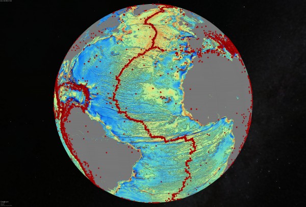
(Photo : David Sandwell, SIO) Gravity model of the North Atlantic. The red dots are earthquakes. Quakes are often related to seamounts.
A new map of the ocean floor reveals the deepest trenches and parts of the ocean previously never seen before.
This map reveals thousands of mountains (or seamounts) that hold clues as to how continents and the Earth formed early on. Earthquakes are often related to the presence of seamounts.
Like Us on Facebook
This new data also helps determine earthquakes caused by seamounts, which were apparently volcanoes during the early formation of the Earth.
According to the National Science Foundation, scientists and researchers consolidated new satellite data and combined it with previous information to produce the new and elaborate map.
Don Rice, program director of the National Science Foundation's Division of Ocean Sciences, said the method that led to the discovery of uncharted regions of the ocean floor provided high resolution details and information about the ocean's floor structure and system, along with its geothermal processes.
He adds this will allow future research that will hopefully answer the mysteries of how the ocean's geophysical processes work, especially those strongly linked to earthquakes and volcanoes.
According to David Sandwell, geophysicist and lead author of the study from the Scripps Institution of Oceanography, the seamounts are abyssal hills and the most common land formations found anywhere on Earth.
This new and improved map of the ocean floor will be pivotal in adding to the information and data scientists possess, especially about seafloor depth. Some 80 percent of the ocean is still uncharted and unexplored.
New features such as the continental seamounts that links South America to Africa along with ridges located in the Gulf of Mexico are now included in Google's Ocean Maps.
Data for this new map of the ocean floor was collected by the European Space Agency's CryoSat-2 satellite used for monitoring polar ice, and NASA's Jason-1 satellite that has been measuring and mapping gravity fields for the past decade.
This particular study is funded by the National Science Foundation and supported by ConocoPhillips, the U.S. Office of Naval Research and the National Geospatial-Intelligence Agency.
TagsSatellite Data Reveals Thousands of Underwater Mountains Never Seen Before, NASA, ESA, National Science Foundation, google ocean maps, seamounts, new ocean map seamounts, seafloor map
©2015 Chinatopix All rights reserved. Do not reproduce without permission
EDITOR'S PICKS
-

Did the Trump administration just announce plans for a trade war with ‘hostile’ China and Russia?
-

US Senate passes Taiwan travel bill slammed by China
-

As Yan Sihong’s family grieves, here are other Chinese students who went missing abroad. Some have never been found
-

Beijing blasts Western critics who ‘smear China’ with the term sharp power
-

China Envoy Seeks to Defuse Tensions With U.S. as a Trade War Brews
-

Singapore's Deputy PM Provides Bitcoin Vote of Confidence Amid China's Blanket Bans
-

China warns investors over risks in overseas virtual currency trading
-

Chinese government most trustworthy: survey
-

Kashima Antlers On Course For Back-To-Back Titles
MOST POPULAR
LATEST NEWS
Zhou Yongkang: China's Former Security Chief Sentenced to Life in Prison

China's former Chief of the Ministry of Public Security, Zhou Yongkang, has been given a life sentence after he was found guilty of abusing his office, bribery and deliberately ... Full Article
TRENDING STORY

China Pork Prices Expected to Stabilize As The Supplies Recover

Elephone P9000 Smartphone is now on Sale on Amazon India

There's a Big Chance Cliffhangers Won't Still Be Resolved When Grey's Anatomy Season 13 Returns

Supreme Court Ruled on Samsung vs Apple Dispute for Patent Infringement

Microsoft Surface Pro 5 Rumors and Release Date: What is the Latest?


