First Images of San Francisco's Deadliest Shipwreck Revealed by Scientists
| Ana Verayo | | Dec 13, 2014 03:33 AM EST |
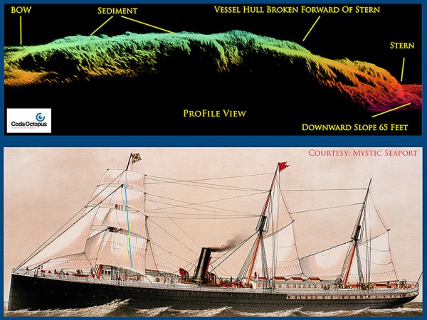
(Photo : NOAA/Mystic Seaport) Top: CodaOctopus 3-D Echoscope sonar profile view of SS City of Rio De Janeiro. Bottom: Painting of SS City of Rio De Janeiro
For the first time ever, images of the ship involved in the most devastating shipwreck in Bay Area history were revealed by the National Oceanic and Atmospheric Administration (NOAA).
Over a century ago, the S.S. City of Rio de Janeiro crashed into jagged rocks in the vicinity of the Golden Gate Bridge and sank, killing 128 passengers and crew, mostly Chinese and Japanese immigrants. This steamship is often referred to as "Bay Area's Titanic" because of the huge loss of life caused by her sinking.
Like Us on Facebook
After two years of study and exploration, NOAA found this wreck of the S.S. City of Rio de Janeiro covered in mud some 287 feet below of the San Francisco Bay.
The ship's position has been known to scientists since the 1980s when salvagers first discovered the wreck.
NOAA in collaboration with Hibbard Inshore and Bay Marine Services used a remotely operated underwater drone equipped with sonar developed by Coda Octopus to scour the seabed for the wreck. This mission produced the very first 3D images of the City of Rio and shows the ship's remains enveloped by abyssal darkness in waters just outside the Golden Gate Bridge.
The team also stumbled upon another shipwreck, the S.S. City of Chester, which was rediscovered last year.
The sonar survey revealed amazing clarity and detail of the shipwrecks, said lead researcher Robert Schwemmer. It also shed light on how both ships sank and what happened to them after their destruction
NOAA's Office of National Marine Sanctuaries Maritime Heritage Program has tracked down the resting place of 200 sunken ships, including four never found before.
TagsFirst Images of San Francisco's Deadliest Shipwreck Revealed by Scientists, NOAA, SS city of rio de janeiro, US, San Francisco, bay area shipwreck, sonar images bay area san francisco shipwreck found, golden gate bridge shipwreck, coda octopus
©2015 Chinatopix All rights reserved. Do not reproduce without permission
EDITOR'S PICKS
-

Did the Trump administration just announce plans for a trade war with ‘hostile’ China and Russia?
-

US Senate passes Taiwan travel bill slammed by China
-

As Yan Sihong’s family grieves, here are other Chinese students who went missing abroad. Some have never been found
-

Beijing blasts Western critics who ‘smear China’ with the term sharp power
-

China Envoy Seeks to Defuse Tensions With U.S. as a Trade War Brews
-

Singapore's Deputy PM Provides Bitcoin Vote of Confidence Amid China's Blanket Bans
-

China warns investors over risks in overseas virtual currency trading
-

Chinese government most trustworthy: survey
-

Kashima Antlers On Course For Back-To-Back Titles
MOST POPULAR
LATEST NEWS
Zhou Yongkang: China's Former Security Chief Sentenced to Life in Prison

China's former Chief of the Ministry of Public Security, Zhou Yongkang, has been given a life sentence after he was found guilty of abusing his office, bribery and deliberately ... Full Article
TRENDING STORY

China Pork Prices Expected to Stabilize As The Supplies Recover

Elephone P9000 Smartphone is now on Sale on Amazon India

There's a Big Chance Cliffhangers Won't Still Be Resolved When Grey's Anatomy Season 13 Returns

Supreme Court Ruled on Samsung vs Apple Dispute for Patent Infringement

Microsoft Surface Pro 5 Rumors and Release Date: What is the Latest?


