New Map Reveals How Acidic the Earth's Oceans Are
| Ana Verayo | | Feb 18, 2015 08:22 AM EST |
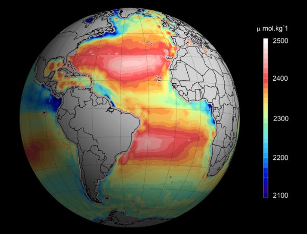
(Photo : Ifremer/ESA/CNES) Temperature and salinity measurements from several satellites have been used to map ocean alkalinity, or the ability of a solution to neutralise acids and thus resist changes in pH.
British scientists have revealed a certain type of technology that can help marine biologists and climate scientists study the ocean using ocean acidification as seen from space.
This new method offers remote monitoring of large areas of the ocean previously inaccessible to satellites orbiting the planet at a distance of 700 kilometers. According to lead researcher Jamie Shutler of the University of Exeter, satellites are a pivotal instrument in monitoring ocean acidification, especially in remote regions and the dangerous, treacherous waters in the Arctic.
Like Us on Facebook
This technique can also slash costs since it's challenging and expensive to conduct yearly direct measurements in remote and inaccessible locations. Scientists are now using these new techniques to monitor the oceans and help quickly identify those regions that are at risk of increasing acidification.
Every year, more than a quarter of the planet's total carbon dioxide emissions originating from burning fossil fuels and cement and industrial production are absorbed by the Earth's oceans.
This process transforms seawater and makes it more acidic. This increased acidification can harm and destroy marine biodiversity and ecosytems.
This rising carbon dioxide emissions along with the increase of acidity in the oceans can devastate marine life and human food source. That's why it's pivotal for scientists to monitor changes in the ocean acidity.
This new technology uses satellites with thermal cameras to measure ocean temperatures and microwave sensors to pick-up salinity. These measurements analyze ocean acidity more quickly and more easily in larger and remote areas compared to previous studies.
Satellites used for the mission include the European Space Agency's Soil Moisture and Ocean Salinity sensor launched in 2009 and NASA's Aquarius satellite launched in 2011.
This study was published in the journal, Environmental Science and Technology.
TagsNew Map Reveals How Acidic the Earth's Oceans Are, ocean acidification, NASA, ESA, oceans earth acid acidification satellite measure map
©2015 Chinatopix All rights reserved. Do not reproduce without permission
EDITOR'S PICKS
-

Did the Trump administration just announce plans for a trade war with ‘hostile’ China and Russia?
-

US Senate passes Taiwan travel bill slammed by China
-

As Yan Sihong’s family grieves, here are other Chinese students who went missing abroad. Some have never been found
-

Beijing blasts Western critics who ‘smear China’ with the term sharp power
-

China Envoy Seeks to Defuse Tensions With U.S. as a Trade War Brews
-

Singapore's Deputy PM Provides Bitcoin Vote of Confidence Amid China's Blanket Bans
-

China warns investors over risks in overseas virtual currency trading
-

Chinese government most trustworthy: survey
-

Kashima Antlers On Course For Back-To-Back Titles
MOST POPULAR
LATEST NEWS
Zhou Yongkang: China's Former Security Chief Sentenced to Life in Prison

China's former Chief of the Ministry of Public Security, Zhou Yongkang, has been given a life sentence after he was found guilty of abusing his office, bribery and deliberately ... Full Article
TRENDING STORY

China Pork Prices Expected to Stabilize As The Supplies Recover

Elephone P9000 Smartphone is now on Sale on Amazon India

There's a Big Chance Cliffhangers Won't Still Be Resolved When Grey's Anatomy Season 13 Returns

Supreme Court Ruled on Samsung vs Apple Dispute for Patent Infringement

Microsoft Surface Pro 5 Rumors and Release Date: What is the Latest?


