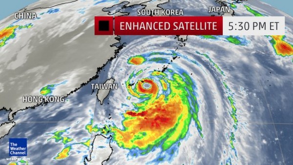
Typhoon Neoguri Enters Japan, Endangering Millions
| Leo J. Magpayo | | Jul 07, 2014 09:01 PM EDT |
(Photo : weather.com)
Neoguri has been reduced to a typhoon with a Category 3 cyclone as it enters the eastern part of Miyakojima in the Okinawa Prefecture of Japan.
Like Us on Facebook
Typhoon Neoguri now has maximum wind speeds of up to 125 mph (183 kph) and wind gusts of up to 155 mph. Its general movement is towards north-northwest at a speed of 14 mph.
Neoguri may have reduced its strength but reminded of the devastating effects left by Hurricane Arthur, Category 2 cyclone, which made landfall in North Carolina of the United States Thursday evening, it has left streets flooded, caused power outages and even pulled trees from its roots.
The tropical storm became a typhoon Friday or an equivalent to that of a hurricane in the Western Pacific and slowly made its way west-northwest over the Pacific. It increased to a Category 4 cyclone Monday as it passes by the waters of the Philippine Islands. It is the strongest tropical cyclone this year so far.
Neoguri is expected to make a major landfall by Wednesday evening at the Prefecture of Kumamoto and traverse the direction towards Hiroshima. It will then lose more strength as it makes its way towards Matsuyama, Osaka, Nagoya, Takashi, Yamagata and Hanamaki before exiting the waters somewhere near Kuji in the Iwate Prefecture of Japan.
Current satellite images show how massive the typhoon is that is capable of dumping huge amounts of rains all over its path. It will also cause howling winds that can uproot trees and even pull-off roofs from houses.
The tail-end of the typhoon is currently at the northwestern tip part of the Philippine Islands and its eye is almost at Miyakojima Island, which is roughly 700 miles northwest, showing how much water Neoguri is carrying.
All are advised to take extreme caution in the path of the storm.
Tagsokinawa, hurricane, cyclone, Storm, flood, power outage, Typhoon Neoguri
©2015 Chinatopix All rights reserved. Do not reproduce without permission
EDITOR'S PICKS
-

Did the Trump administration just announce plans for a trade war with ‘hostile’ China and Russia?
-

US Senate passes Taiwan travel bill slammed by China
-

As Yan Sihong’s family grieves, here are other Chinese students who went missing abroad. Some have never been found
-

Beijing blasts Western critics who ‘smear China’ with the term sharp power
-

China Envoy Seeks to Defuse Tensions With U.S. as a Trade War Brews
-

Singapore's Deputy PM Provides Bitcoin Vote of Confidence Amid China's Blanket Bans
-

China warns investors over risks in overseas virtual currency trading
-

Chinese government most trustworthy: survey
-

Kashima Antlers On Course For Back-To-Back Titles
MOST POPULAR
LATEST NEWS
Zhou Yongkang: China's Former Security Chief Sentenced to Life in Prison

China's former Chief of the Ministry of Public Security, Zhou Yongkang, has been given a life sentence after he was found guilty of abusing his office, bribery and deliberately ... Full Article
TRENDING STORY

China Pork Prices Expected to Stabilize As The Supplies Recover

Elephone P9000 Smartphone is now on Sale on Amazon India

There's a Big Chance Cliffhangers Won't Still Be Resolved When Grey's Anatomy Season 13 Returns

Supreme Court Ruled on Samsung vs Apple Dispute for Patent Infringement

Microsoft Surface Pro 5 Rumors and Release Date: What is the Latest?


