Laser Technology and Computer Algorithms to Help Monitor Nature Reserve Areas
| Sami Ghanmi | | Apr 15, 2015 08:00 PM EDT |
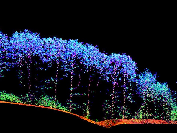
(Photo : Vienna University of Technology) With the laser data, a 3D map of the surface vegetation can be obtained.
As more advanced monitoring technologies are beginning to make their way into various industries such as agriculture, researchers and ecologists are faced with a new challenge that requires monitoring ecological conditions of nature reserve areas which cover vast distances.
Nature reserve areas in the European Union for example, cover almost one fifth of the region, according to a report, making it very difficult to inspect and monitor.
Like Us on Facebook
A team of scientists from the Vienna University of Technology in Austria has approached this challenge by developing a new method that uses aircraft equipped with laser technology and computer algorithms.
The method involves sending laser pulses from above to the ground and retrieving three-dimensional (3D) data maps using computer algorithms and software.
"This can only be achieved with the help of remote sensing." said Norbert Pfeifer, a professor at the university.
"Our team has developed special classification software which can use this data to distinguish different types of vegetation," Pfeifer added.
The 3D map will contain detailed information about the surface vegetation including the lower layers.
"When people process remote sensing data for ecological monitoring, they usually focus on very specific parameters which are easy to derive," said Pfeifer.
"Our approach is quite different. We use the data to calculate precisely the same parameters as they are collected in a site inspection by human ecologists."
"This study is a major step forward in closing the gap between the remote sensing and conservation ecology communities," said András Zlinszky, from the Centre for Ecological Research in Hungary.
"We have shown that it is possible to monitor Natura 2000 conservation status by remote sensing, exactly following the rules laid out by the local ecology experts."
TagsVienna University of Technology, Austria, laser technology, computer algorithm, Centre for Ecological Research, hungary, Nature Reserve Area, EU
©2015 Chinatopix All rights reserved. Do not reproduce without permission
EDITOR'S PICKS
-

Did the Trump administration just announce plans for a trade war with ‘hostile’ China and Russia?
-

US Senate passes Taiwan travel bill slammed by China
-

As Yan Sihong’s family grieves, here are other Chinese students who went missing abroad. Some have never been found
-

Beijing blasts Western critics who ‘smear China’ with the term sharp power
-

China Envoy Seeks to Defuse Tensions With U.S. as a Trade War Brews
-

Singapore's Deputy PM Provides Bitcoin Vote of Confidence Amid China's Blanket Bans
-

China warns investors over risks in overseas virtual currency trading
-

Chinese government most trustworthy: survey
-

Kashima Antlers On Course For Back-To-Back Titles
MOST POPULAR
LATEST NEWS
Zhou Yongkang: China's Former Security Chief Sentenced to Life in Prison

China's former Chief of the Ministry of Public Security, Zhou Yongkang, has been given a life sentence after he was found guilty of abusing his office, bribery and deliberately ... Full Article
TRENDING STORY

China Pork Prices Expected to Stabilize As The Supplies Recover

Elephone P9000 Smartphone is now on Sale on Amazon India

There's a Big Chance Cliffhangers Won't Still Be Resolved When Grey's Anatomy Season 13 Returns

Supreme Court Ruled on Samsung vs Apple Dispute for Patent Infringement

Microsoft Surface Pro 5 Rumors and Release Date: What is the Latest?


