China Uses Satellites To Communicate With Fishing Vessels In Disputed Waters
| Bianca Ortega | | Jul 29, 2014 01:47 AM EDT |
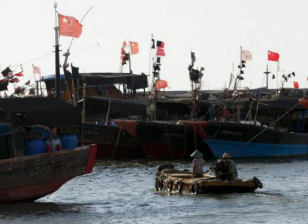
(Photo : Reuters / John Ruwitch) A dinghy ferries people to fishing boats at a port in the city of Dongfang on the western side of China's palm-fringed island province of Hainan, June 18, 2014.
Chinese authorities encourage fishermen in Hainan to venture out to disputed waters by installing communication satellites on their boats and providing them with fuel subsidies for the trips.
The provision of satellites and fuel subsidies is a sign that China is beefing up support for its local fishermen who are heading further into Southeast Asia to find new fishing areas as its resources back home grow increasingly scarce. This issue puts Chinese fishing vessels on the spotlight amid one of Asia's most controversial issues, Reuters reported.
Like Us on Facebook
China recently became more assertive in the South China Sea in its bid to establish its ownership claims on several disputed areas and to increase its gas and oil output. However, experts said one of the main reasons for this assertiveness is the depleted supply of seafood to the Chinese market.
Based on a report by the Food and Agriculture Organization (FAO) this year, China's consumption of fish in 2010 was 35.1 kilograms per capita. This number is almost twice the global average of 18.9 kilograms.
Alan Dupont, international security professor at the University of New South Wales, said fish products are "critical" to the Chinese lifestyle but people still do not see it as a main factor in China's territorial spats. The Chinese government is encouraging its fishing fleet to venture out to disputed waters not only for geopolitical reasons, but for "economic and commercial" purposes as well.
A fishing boat captain in Hainan island showed a Reuters reporter a satellite navigation system installed on his old vessel which allows him to communicate with the Chinese coastguard in case he runs into foreign patrol ships, bad weather, or mechanical problems. By 2013, over 50,000 Chinese fishing vessels already installed the Beidou satellite system on their boats.
The boat captains shouldered only 10 percent of the Beidou satellite's cost, while the Chinese government paid for the rest. The satellite system competes with the Global Positioning System (GPS) of the U.S. and the GLONASS of Russia. The Chinese army also started using the Beidou, or the Big Dipper.
Fishermen could also use the Beidou to connect with other fishermen or their family and friends using its short messaging system. With just a push of the emergency button, Chinese authorities receive a message from the fishing vessel in distress and allow them to pinpoint its exact location.
Since March 2013, when President Xi Jinping took his position, Beijing became more aggressive in asserting its ownership of Southeast Asian waters that are also claimed by Vietnam, Malaysia, Taiwan, Brunei, and the Philippines.
Surely, China has other more important reasons to stake its claim in the disputed waters as the State Oceanic Administration's October 2012 study found that the fish stocks in the Chinese coast were declining. Zhang Hongzhou, S. Rajaratnam School of International Studies associate research fellow, agreed that the main cause of the tensions over territorial disputes is the "competition for fishing resources."
TagsBeidou, fishing vessels
©2015 Chinatopix All rights reserved. Do not reproduce without permission
EDITOR'S PICKS
-

Did the Trump administration just announce plans for a trade war with ‘hostile’ China and Russia?
-

US Senate passes Taiwan travel bill slammed by China
-

As Yan Sihong’s family grieves, here are other Chinese students who went missing abroad. Some have never been found
-

Beijing blasts Western critics who ‘smear China’ with the term sharp power
-

China Envoy Seeks to Defuse Tensions With U.S. as a Trade War Brews
-

Singapore's Deputy PM Provides Bitcoin Vote of Confidence Amid China's Blanket Bans
-

China warns investors over risks in overseas virtual currency trading
-

Chinese government most trustworthy: survey
-

Kashima Antlers On Course For Back-To-Back Titles
MOST POPULAR
LATEST NEWS
Zhou Yongkang: China's Former Security Chief Sentenced to Life in Prison

China's former Chief of the Ministry of Public Security, Zhou Yongkang, has been given a life sentence after he was found guilty of abusing his office, bribery and deliberately ... Full Article
TRENDING STORY

China Pork Prices Expected to Stabilize As The Supplies Recover

Elephone P9000 Smartphone is now on Sale on Amazon India

There's a Big Chance Cliffhangers Won't Still Be Resolved When Grey's Anatomy Season 13 Returns

Supreme Court Ruled on Samsung vs Apple Dispute for Patent Infringement

Microsoft Surface Pro 5 Rumors and Release Date: What is the Latest?


