Study: Nepal Earthquake Landslides Could Have Been More Devastating
| Ana Verayo | | Dec 17, 2015 06:10 AM EST |
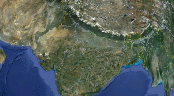
(Photo : UANews/Google Earth) Pushing north against the Eurasian Plate, the Indian Plate dives into the Earth's interior, pushing up the Himalayas in the process. At the contact zone, visible as an arch in this Google Earth image, immense stress builds up, causing earthquakes including devastating ones like the one in Nepal.
Scientists say that the devastating impacts from the Nepal earthquakes earlier this year could apparently been much more worse.
In this new study, an international team of scientists revealed that the number of landslides that resulted from the earthquakes are far lower that people feared them to be. The team also revealed how there was also no evidence that the Himalayan glacial lakes received any significant damage which is a major concern.
Like Us on Facebook
According to lead author of the study, Jeffery Kargel of the University of Arizona, Tucson, there were a lot of surprises about the earthquakes' influence on the landscape, ranging from the largest to the smaller scales, which were not at all expected.
It is still true that the aftermath of the Nepal quakes last April and May were devastating, as more than 8,500 people died. Researchers still believe that this horrible outcome was minimal compared to what could have occurred.
The April 25 tremor registered a main magnitude of 7.8, buckling the Earth's surface where this resulted in a broad swathe of the high Himalayan mountains to slump down as it lifted the Kathmandu basin. This entire region also shifted by two meters to the south.
Scientists immediately expected more than 10,000 landslides to follow after this that can trigger more devastation however, based on satellite images, there were only 4,312 landslides identified.
Apart from this, researchers also first thought that the lakes that are located behind rocky deposits of glaciers will be triggered by tremors, that should have sent torrents of water down in the Nepal valleys. Despite the quakes, satellite images and ground surveys and inspections could not find any severe damages.
Now, scientists speculate several factors why more devastating events were not triggered by the Nepal earthquakes. One could be the shaking, as even if it was energetic, the overall result was relatively smooth. Rock strength within the region could have also been underestimated including the forests filled with rhododendrons, which could be the key to keeping the landscape intact.
Still, this does not diminish the fact about the devastation of Nepal and the lives that were lost especially in the famous trekking village of Langtang in northern Kathmandu, where 2 million cubic meters of debris fell from the mountains.
Scientists calculated the total mass of snow, ice and rock that crashed in the valley floor, resulting in an energy equivalent to a Hiroshima nuclear bomb. A region of Langtang was destroyed instantly with only this airblast.
Another part of a village was also completely blown away by the landslide or by avalanche winds, as strong as an EF-5 tornado, completely blowing away stone slab hotels. There were also more than 350 people who perished in Langtang.
This new study is published in Science.
Tagsnepal earthquakes, himalayan mountains, nepal earthquakes landslides, fewer landslides than expected from nepal earthquakes, nepal quake landslides, langtang nepal
©2015 Chinatopix All rights reserved. Do not reproduce without permission
EDITOR'S PICKS
-

Did the Trump administration just announce plans for a trade war with ‘hostile’ China and Russia?
-

US Senate passes Taiwan travel bill slammed by China
-

As Yan Sihong’s family grieves, here are other Chinese students who went missing abroad. Some have never been found
-

Beijing blasts Western critics who ‘smear China’ with the term sharp power
-

China Envoy Seeks to Defuse Tensions With U.S. as a Trade War Brews
-

Singapore's Deputy PM Provides Bitcoin Vote of Confidence Amid China's Blanket Bans
-

China warns investors over risks in overseas virtual currency trading
-

Chinese government most trustworthy: survey
-

Kashima Antlers On Course For Back-To-Back Titles
MOST POPULAR
LATEST NEWS
Zhou Yongkang: China's Former Security Chief Sentenced to Life in Prison

China's former Chief of the Ministry of Public Security, Zhou Yongkang, has been given a life sentence after he was found guilty of abusing his office, bribery and deliberately ... Full Article
TRENDING STORY

China Pork Prices Expected to Stabilize As The Supplies Recover

Elephone P9000 Smartphone is now on Sale on Amazon India

There's a Big Chance Cliffhangers Won't Still Be Resolved When Grey's Anatomy Season 13 Returns

Supreme Court Ruled on Samsung vs Apple Dispute for Patent Infringement

Microsoft Surface Pro 5 Rumors and Release Date: What is the Latest?


