Teen Discovers Lost Ancient Mayan City Via Google Maps
| Ana Verayo | | May 11, 2016 01:49 AM EDT |
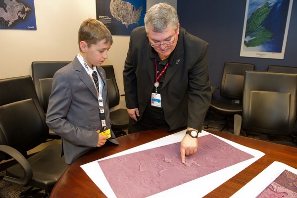
(Photo : Canadian Space Agency/Facebook) Gadoury, 15, discovered a lost Mayan city in Belize with Google Maps.
A 15 year old boy from Canada claims to have discovered a lost Mayan civilization deep inside the jungles of South America using Google Maps.
William Gadoury from Quebec, used an ingenious method by overlaying ancient Mayan constellation maps over important ancient Mayan cities, where he believes he saw some structures that somewhat resemble one of these cities, in Belize. Using these two maps, the Mayan cities appear to possess a master plan that is similar to important stellar constellations.
Like Us on Facebook
However, Gadoury noticed that a city seems to be missing from the maps. There was this single star from the constellation map that did not match with any known Mayan city in that area. The teenager then thought that if there is an important star on that area, it must correspond to a hidden city, where he then proceeded to search for it via Google Earth.
In his surprise, Gadoury successfully located this previously missing and unknown Mayan city and also verified that his theory was correct, that ancient Mayans use important constellation maps for city planning.
By using transparencies from these constellations, he laid them out on top of maps obtained from Google Earth, across the Yucatan peninsula in Mexico, where he was surprised to see how perfectly aligned the Mayan cities to the Yucatan.
In his research, Gadoury discovered 117 Mayan cities out of those 142 stars from the ancient constellation maps, where the biggest cities and capitals also correspond to the brightest stars. When he discovered this lost ancient city, the 23rd constellation from the map revealed some telltale clues.
Gadoury then checked his information with the Canadian Space Agency where the agency provided him with NASA and JAXA Japanese Agency satellite maps. In that particular region, Gadoury quickly discovered in the satellite images that a great forest fire in 2005 devastated the region which was also an advantage for him since this enabled him to make out the remnants from the Mayan city.
Based on the satellite images, the ancient city appeared to be the fourth largest Mayan city to be found, where Gadoury named this lost city K'AAK 'CHI, which means "Fire Mouth".
Gadoury's findings also reveal that the Mayans have meticulously selected the locations of their cities than previously known, indicating extremely controlled city planning. The Mayans apparently possess land surveying methods that are far more complex than previously thought, as they have mapped out 117 cities to match with the stars in their constellation maps, via Gadoury's discovery.
Tagsmayan civilizations, lost mayan city, ancient civilizations, Mayan, mayan maps
©2015 Chinatopix All rights reserved. Do not reproduce without permission
EDITOR'S PICKS
-

Did the Trump administration just announce plans for a trade war with ‘hostile’ China and Russia?
-

US Senate passes Taiwan travel bill slammed by China
-

As Yan Sihong’s family grieves, here are other Chinese students who went missing abroad. Some have never been found
-

Beijing blasts Western critics who ‘smear China’ with the term sharp power
-

China Envoy Seeks to Defuse Tensions With U.S. as a Trade War Brews
-

Singapore's Deputy PM Provides Bitcoin Vote of Confidence Amid China's Blanket Bans
-

China warns investors over risks in overseas virtual currency trading
-

Chinese government most trustworthy: survey
-

Kashima Antlers On Course For Back-To-Back Titles
MOST POPULAR
LATEST NEWS
Zhou Yongkang: China's Former Security Chief Sentenced to Life in Prison

China's former Chief of the Ministry of Public Security, Zhou Yongkang, has been given a life sentence after he was found guilty of abusing his office, bribery and deliberately ... Full Article
TRENDING STORY

China Pork Prices Expected to Stabilize As The Supplies Recover

Elephone P9000 Smartphone is now on Sale on Amazon India

There's a Big Chance Cliffhangers Won't Still Be Resolved When Grey's Anatomy Season 13 Returns

Supreme Court Ruled on Samsung vs Apple Dispute for Patent Infringement

Microsoft Surface Pro 5 Rumors and Release Date: What is the Latest?


