DARPA Perfecting Undersea GPS Called POSYDON
| Arthur Dominic Villasanta | | Jun 06, 2016 05:45 AM EDT |
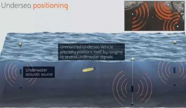
(Photo : DARPA) POSYDON schematic
The first practical undersea equivalent of the land-based global positioning system (GPS) is being developed by the U.S. Defense Advanced Research Projects Agency (DARPA) and contractor BAE Systems.
Named POSYDON, an acronym for the "Positioning System for Deep Ocean Navigation" program, the world's first global undersea GPS will be for U.S. Navy use only. Sorry, John Q. Public, for now at least.
Like Us on Facebook
POSYDON will allow U.S. Navy submarines, submersibles and unmanned underwater vehicles (UUVs) to better navigate and be better concealed by the murky ocean depths while remaining hidden from their Chinese and Russian foes.
POSYDON aims to develop an undersea system that is omnipresent; is capable of robust positioning, navigation and timing independent of GPS and inertial navigation. By using a small number of long-range acoustic sources, an attack or nuclear missile submarine will be able to obtain continuous, accurate positioning without surfacing for a GPS fix.
Phase I of the program focuses on accurately modeling the signal propagation channel while Phase II focuses on developing the signal waveform. A complete positioning system is scheduled to be demonstrated in Phase III.
BAE is developing technology that relies on long-range acoustic sources at fixed locations in the oceans. Using POSYDON, submarines and other US Navy undersea weapons will determine their location by ranging to the acoustic signals from several of the fixed underwater sources.
POSYDON also removes the need for a submarine to either surface or ascend to a shallow depth to communicate with the outside world, a dangerous action in wartime.
BAE Systems has over 40 years of experience developing underwater active and passive acoustic systems, said Joshua Niedzwiecki, BAE Systems director of Sensor Processing and Exploitation.
"We'll use this same technology to revolutionize undersea navigation for the POSYDON program, by selecting and demonstrating acoustic underwater GPS sources and corresponding small-form factor receivers."
TagsU.S. Defense Advanced Research Projects Agency, DARPA, POSYDON, Positioning System for Deep Ocean Navigation, GPS, U.S. Navy
©2015 Chinatopix All rights reserved. Do not reproduce without permission
EDITOR'S PICKS
-

Did the Trump administration just announce plans for a trade war with ‘hostile’ China and Russia?
-

US Senate passes Taiwan travel bill slammed by China
-

As Yan Sihong’s family grieves, here are other Chinese students who went missing abroad. Some have never been found
-

Beijing blasts Western critics who ‘smear China’ with the term sharp power
-

China Envoy Seeks to Defuse Tensions With U.S. as a Trade War Brews
-

Singapore's Deputy PM Provides Bitcoin Vote of Confidence Amid China's Blanket Bans
-

China warns investors over risks in overseas virtual currency trading
-

Chinese government most trustworthy: survey
-

Kashima Antlers On Course For Back-To-Back Titles
MOST POPULAR
LATEST NEWS
Zhou Yongkang: China's Former Security Chief Sentenced to Life in Prison

China's former Chief of the Ministry of Public Security, Zhou Yongkang, has been given a life sentence after he was found guilty of abusing his office, bribery and deliberately ... Full Article
TRENDING STORY

China Pork Prices Expected to Stabilize As The Supplies Recover

Elephone P9000 Smartphone is now on Sale on Amazon India

There's a Big Chance Cliffhangers Won't Still Be Resolved When Grey's Anatomy Season 13 Returns

Supreme Court Ruled on Samsung vs Apple Dispute for Patent Infringement

Microsoft Surface Pro 5 Rumors and Release Date: What is the Latest?


