Dead Zone in Gulf of Mexico Predicted to be as Big as Connecticut
| Ana Verayo | | Jun 12, 2016 07:27 AM EDT |
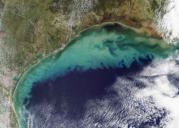
(Photo : Jeff Schmaltz (NASA Earth Observatory)) 2009 satellite image of the Gulf of Mexico. Much of the dirt that colours the water is likely re-suspended sediment dredged up from the sea floor in shallow waters. The tan-green sediment-coloured water transitions to clearer dark blue water near the edge of the continental shelf where the water becomes deeper. The ocean turbulence that brought the sediment to the surface is readily evident in the textured waves and eddies within the tan and green waters.
New data predictions reveal how the Dead Zone located in the Gulf of New Mexico can span across a region so huge, it can become comparable to the state of Connecticut or almost 5,900 square miles, where little to almost no life forms can exist in here.
Like Us on Facebook
Dead zones or hypoxic zones are caused by land runoff from agricultural waste, seeping into waterways like streams and lakes and eventually reaching the oceans. This waste is composed mostly of nitrogen and phosphorus that are originally from livestock waste which can greatly affect bodies of water within the region, sucking out oxygen from water. Marine plants and animals are at risk of dying from suffocation since oxygen is not present in these bodies of water.
In this new study, researchers predicted the size of this dead zone to be typical during summer, which is still an alarming area size. For this latest prediction, four computer models were developed resulting in this newest analysis, between 5,204 square miles to 6,823 square miles, excluding several environmental factors like hurricanes and tropical storms.
The Gulf of Mexico in the northeastern United States that spans the coastlines of Texas, Louisiana and Florida, is known for its rich ecosystem and biodiversity, where many species thrive. According to Russell Callender from the National Ocean Service, dead zones are threatening gulf fisheries and fishing communities which is why these new predictions can help develop better predictive models with new tools and resources, ultimately providing up to date information to communities and industries.
Since 2001, the Mississippi River/Gulf of Mexico Watershed Nutrient Task Force has been aiming to prevent the size of this dead zone from increasing, down to an average of 1,950 square miles. Between 1995 and 2015, this oxygen depleted zone possessed an alarming average of 5,942 square miles.
According to ecologist Don Scavia of the Graham Sustainability Institute at the University of Michigan, this latest forecast reveals an average sized dead zone but averages are still unacceptable, he says. The action's plan goal is to bring it down to 1,950 square miles and to initiate more serious measures and actions to reduce midwest fertilizer loss that has been leaking into the Mississippi River system.
Predictions are carried out every year by NOAA (National Oceanic and Atmospheric Administration) for hypoxic zones found in the Gulf of Mexico including Lake Erie and Chesapeake Bay.
Tagsdead zones, Gulf of Mexico, hypoxic zones, hypoxia, Marine Ecosystems, NOAA
©2015 Chinatopix All rights reserved. Do not reproduce without permission
EDITOR'S PICKS
-

Did the Trump administration just announce plans for a trade war with ‘hostile’ China and Russia?
-

US Senate passes Taiwan travel bill slammed by China
-

As Yan Sihong’s family grieves, here are other Chinese students who went missing abroad. Some have never been found
-

Beijing blasts Western critics who ‘smear China’ with the term sharp power
-

China Envoy Seeks to Defuse Tensions With U.S. as a Trade War Brews
-

Singapore's Deputy PM Provides Bitcoin Vote of Confidence Amid China's Blanket Bans
-

China warns investors over risks in overseas virtual currency trading
-

Chinese government most trustworthy: survey
-

Kashima Antlers On Course For Back-To-Back Titles
MOST POPULAR
LATEST NEWS
Zhou Yongkang: China's Former Security Chief Sentenced to Life in Prison

China's former Chief of the Ministry of Public Security, Zhou Yongkang, has been given a life sentence after he was found guilty of abusing his office, bribery and deliberately ... Full Article
TRENDING STORY

China Pork Prices Expected to Stabilize As The Supplies Recover

Elephone P9000 Smartphone is now on Sale on Amazon India

There's a Big Chance Cliffhangers Won't Still Be Resolved When Grey's Anatomy Season 13 Returns

Supreme Court Ruled on Samsung vs Apple Dispute for Patent Infringement

Microsoft Surface Pro 5 Rumors and Release Date: What is the Latest?


