China Launches Gaofen-3 High-Resolution Imaging Satellite for Civilian Use
| Charissa Echavez | | Aug 11, 2016 02:56 PM EDT |
(Photo : Getty Images/ Paolo Nespoli - ESA/NASA) In this handout image provided by the European Space Agency (ESA) and NASA, the International Space Station and the docked space shuttle Endeavour orbit Earth during Endeavour's final sortie in Space.
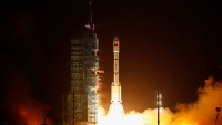
China launched a new synthetic aperture radar (SAR) imaging satellite called Gaofen-3 on Wednesday at 6:55 p.m. (Eastern Time) from the Taiyuan Satellite Launch Center in northern Shanxi Province.
According to Xinhua, the satellite, which was launched on a Long March 4C, is equipped with a radar payload that can produce high-resolution images of one meter. It will be used for civil applications such as 24-hour environmental monitoring, weather forecasting, disaster monitoring, and water resource assessments.
Like Us on Facebook
"The launch of Gaofen-3 is expected to reduce dependence on data provided by foreign microwave imaging satellites," Jiang XIngwei, deputy chief engineer of Gaofen satellite application system, said.
IBTimes reported that Gaofen-3 would also be utilized to protect China's maritime rights interests especially with the growing tension in the South China Sea. "The satellite will play an important role in monitoring the marine environment, islands and reefs, and ships and oil rigs," Xu Fuxiang, head of Gaofen-3 project, said.
The new satellite was developed by Beijing-based China Academy of Space Technology and has a lifespan of eight years. Boasting of its 12 imaging modes, Gaofen-3 is the best player among the SAR family as it can easily switch into different settings, with the ability to take photos on land or water and detailed photos of particular locations.
Gaofen-3 also features spatial resolution ranging between 1 meter and 400 meters, and its broadest viewing spectrum could reach up to 65- kilometers. It can reportedly produce clear photos of all roads, buildings, and boats, Shanghai Daily reported.
This is the first Chinese satellite that will cater to civilian users and would "serve many different needs of many different users," Professor Wu Shunkin, a radar technology expert from the National Lab of Radar Signal Processing in Xidian University, told the South China Morning Post.
TagsGaofen-3, high resolution satellite, radar imaging satellte, synthetic aperture radar, Orbit, Satellite
©2015 Chinatopix All rights reserved. Do not reproduce without permission
EDITOR'S PICKS
-

Did the Trump administration just announce plans for a trade war with ‘hostile’ China and Russia?
-

US Senate passes Taiwan travel bill slammed by China
-

As Yan Sihong’s family grieves, here are other Chinese students who went missing abroad. Some have never been found
-

Beijing blasts Western critics who ‘smear China’ with the term sharp power
-

China Envoy Seeks to Defuse Tensions With U.S. as a Trade War Brews
-

Singapore's Deputy PM Provides Bitcoin Vote of Confidence Amid China's Blanket Bans
-

China warns investors over risks in overseas virtual currency trading
-

Chinese government most trustworthy: survey
-

Kashima Antlers On Course For Back-To-Back Titles
MOST POPULAR
LATEST NEWS
Zhou Yongkang: China's Former Security Chief Sentenced to Life in Prison

China's former Chief of the Ministry of Public Security, Zhou Yongkang, has been given a life sentence after he was found guilty of abusing his office, bribery and deliberately ... Full Article
TRENDING STORY

China Pork Prices Expected to Stabilize As The Supplies Recover

Elephone P9000 Smartphone is now on Sale on Amazon India

There's a Big Chance Cliffhangers Won't Still Be Resolved When Grey's Anatomy Season 13 Returns

Supreme Court Ruled on Samsung vs Apple Dispute for Patent Infringement

Microsoft Surface Pro 5 Rumors and Release Date: What is the Latest?


