China Building More Radar Stations on the Spratly Islands
| Arthur Dominic Villasanta | | Aug 25, 2016 10:15 AM EDT |
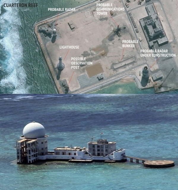
(Photo : CSIS/Philippine Navy) Chinese radars on Cuarteron Reef (top) and Subi Reef (bottom).
China continues building military radar stations on seven reefs in the Spratly Islands, some of which it seized illegally from the Philippines, that extend the coverage zone of its anti-access, anti-denial (A2/AD) network in the South China Sea.
Military radar stations have been built on Cuarteron Reef, Fiery Cross Reef, Gaven Reef, Hughes Reef, Johnson Reef, Mischief Reef and Subi Reef, according to the Asia Maritime Transparency Initiative (AMTI), an interactive website that aims to promote transparency in the Indo-Pacific to dissuade assertive behavior and conflict. It also works to generate opportunities for cooperation and confidence building.
Like Us on Facebook
AMTI's website can be seen here. AMTI was conceived of and designed by Center for Strategic and International Studies (CSIS), a U.S. think tank based in Washington D.C. AMTI says it and CSIS take no position on territorial or maritime claims.
AMTI believes these Chinese radar stations constitute a network that together significantly expand the real-time domain awareness and intelligence, surveillance and reconnaissance (ISR) capabilities of the People's Liberation Army (PLA) over a large portion of the South China Sea. The stations will allow China to better track military aircraft of the United States, the Philippines, Vietnam and other nations standing-up to China's coercive diplomacy.
China keeps insisting these radar installations will be used to support search and rescue. Experts said the reality is these stations are critical to the PLA's keeping control of the islands China should have returned to its rightful owners following the July 12 decision by the Permanent Court of Arbitration in The Hague that nullified China's nine-dash line and with it China's claim to own the South China Sea.
AMTI said these dispersed radar systems extend the PLA's ISR capabilities throughout the South China Sea. It will allow better real-time tracking of warships and military aircraft transiting the South China Sea.
AMTI also noted that China is building satellite uplink equipment to its Beidou-GPS system on many of the features. Satellite communications equipment permits reliable over-the-horizon targeting for China's anti-ship ballistic missiles. It also extends the zone covered by China's A2/AD network to maneuvering targets such as U.S. Navy aircraft carrier strike groups and other Navy warships.
Tagschina, seven reefs, spratly islands, South China Sea, radar stations, Asia Maritime Transparency Initiative, Center for Strategic and International Studies, nine dash line
©2015 Chinatopix All rights reserved. Do not reproduce without permission
EDITOR'S PICKS
-

Did the Trump administration just announce plans for a trade war with ‘hostile’ China and Russia?
-

US Senate passes Taiwan travel bill slammed by China
-

As Yan Sihong’s family grieves, here are other Chinese students who went missing abroad. Some have never been found
-

Beijing blasts Western critics who ‘smear China’ with the term sharp power
-

China Envoy Seeks to Defuse Tensions With U.S. as a Trade War Brews
-

Singapore's Deputy PM Provides Bitcoin Vote of Confidence Amid China's Blanket Bans
-

China warns investors over risks in overseas virtual currency trading
-

Chinese government most trustworthy: survey
-

Kashima Antlers On Course For Back-To-Back Titles
MOST POPULAR
LATEST NEWS
Zhou Yongkang: China's Former Security Chief Sentenced to Life in Prison

China's former Chief of the Ministry of Public Security, Zhou Yongkang, has been given a life sentence after he was found guilty of abusing his office, bribery and deliberately ... Full Article
TRENDING STORY

China Pork Prices Expected to Stabilize As The Supplies Recover

Elephone P9000 Smartphone is now on Sale on Amazon India

There's a Big Chance Cliffhangers Won't Still Be Resolved When Grey's Anatomy Season 13 Returns

Supreme Court Ruled on Samsung vs Apple Dispute for Patent Infringement

Microsoft Surface Pro 5 Rumors and Release Date: What is the Latest?


